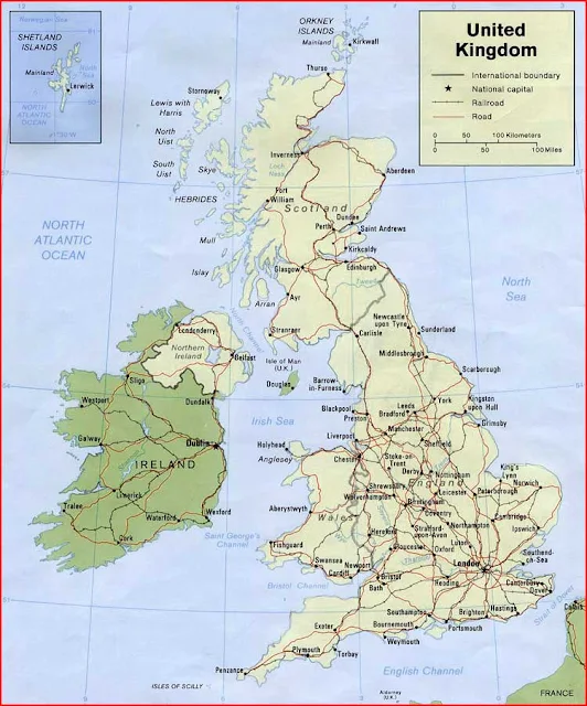
United Kingdom Map High Resolution
United Kingdom Bordering Countries: Ireland
Regional Maps: Map of Europe, World Map
Countries in map: England, Scotland, Northern Ireland, Wales
Political map
Important city of United Kingdom: Aberdeen, Aberystwyth, Antrim, Armagh, Ayr, Ballycastle, Barnsley, Barrow-in-Furness, Bath, Belfast, Birmingham, Blackpool, Bournemouth, Bradford, Brighton, Bristol, Caernarfon, Cambridge, Canterbury, Cardiff, Carlisle, Carmarthen, Chelmsford, Cheltenham, Chester, Chichester, Coleraine, Cookstown, Coventry, Cupar, Derby, Doncaster, Dorchester, Dover, Downpatrick, Dumfries, Dundee, Durham, Edinburgh, Exeter, Falkirk, Fishguard, Fort William, Glasgow, Gloucester, Grimsby, Hamilton, Hastings, Hereford, Holyhead, Inverness, Ipswich, King's Lynn, Kingston upon Hull, Kirkcaldy, Kirkwall, Larne, Leeds, Leicester, Lerwick, Lewes, Lincoln, Liverpool, London, Londonderry, Luton, Maidstone, Manchester, Mansfield, Matlock, Middlesbrough, Mold, Motherwell, Newcastle upon Tyne, Newport, Newry, Newton Saint Boswells, Northallerton, Northampton, Norwich, Nottingham, Oban, Oxford, Penzance, Perth, Peterborough, Plymouth, Portsmouth, Preston, Reading, Reigate, Saint Andrews, Salisbury, Scarborough, Sheffield, Shrewsbury, South Shields, Southampton, Southend-on-Sea, Stafford, Stockport, Stoke-on-Trent, Stornoway, Stranraer, Stratford-upon-Avon, Stroud, Sunderland, Swansea, Thurso, Torbay, Trowbridge, Truro, Ullapool, Wakefield, Warwick, West Bromwich, Weymouth, Winchester, Wolverhampton, Wokingham, Workington, and York.


